Tuesday, February 28, 2017

Wind Advisory - Low Visibility

We woke up this morning to a NOAA Wind Advisory and in New Mexico and Texas that means dust!

From the RV park we couldn't even see the surrounding hills and mountains.

We needed to drive down to El Paso to pick up the car and as soon as we got on I-10 we encountered these... 

warning signs.

 Not that we needed signs to tell us poor visibility!

Looks like a blizzard in New England!

We left New Mexico and...

entered Texas, the Lone Star State.

We were able to retrieve our car and by the time we made a quick stop at Costco and started to drive back, the wind had subsided somewhat. 

We have our tow vehicle back and we're ready to move on.

Monday, February 27, 2017

Dripping Springs Trail

Everyone that we asked about hiking trails mentioned Dripping Springs so that was our destination today. Located on the other side of New Mexico State University, in the Organ Mountains-Desert Peaks National Monument, it is 16-miles and 30 minutes away from our RV park.

Heading into the Organ Mountains on the Dripping Springs Trail.

There are several historic structures at the end of the trail in the Ice Canyon. At one time, in the early 1900s, this building served as a Sanatorium for TB patients.

This it IT! - Dripping Springs!!

Colonel Eugene Van Patten, who served in the Confederacy during the Civil War, came to Mesilla at the invitation of his uncle, John Butterfield, who operated the Butterfield Stage Line. Van Patten built a resort at Dripping Springs in the 1870s. These ruins are all that remain today.

It had 16 rooms, a large dining room, and a concert hall. It was very popular around the turn of the century and many famous people, including Pat Garret and Pancho Villa, stayed here.

Turning around from the resort ruins we had this view of Las Cruces in the valley below - 2,000 feet below, to be exact.

Organ Mountains up-close.

Since the Dripping Springs Trail is only 2.5 miles, we decided to tack on the Crawford and La Cueva Trails.

La Cueva Rocks north of the Visitor Center. Note the large rock on the left. At the base of that rock is...

this cave.

Still to be excavated, there is a midden on the floor of the cave.

I think people were shorter in the old days.

Passing along the south side of La Cueva Rocks.

Further along the trail we stopped to locate the cave at the base of the rocks. We are standing on the other side of an arroyo. This picture is taken with the zoom lens and...

for this picture, we are standing in the same spot, but using a wide lens.

La Cueva Rocks on the edge of Las Cruces valley.

Today's hike:
Length - 5.16 miles
Duration - 2 hours, 45 minutes
Elevation gain - 980 feet (99 floors on the Fitbit)

Sunday, February 26, 2017

Mesilla

Mesilla's founding dates from 1848, when residents of a nearby community that had become part of the United States as a result of the Treaty of Guadalupe Hidalgo elected to relocate in order to retain Mexican citizenship. They were awarded a Mexican land grant in 1850, but in 1854, a detachment from nearby Fort Fillmore raised the U.S. flag here confirming the Gadsden Purchase and La Mesilla was officially recognized as part of the U.S.  During the Civil War, Mesilla was the capital of Confederate Arizona Territory.

Productive farmland and a strategic location spurred growth. By the time the Butterfield Trail Overland mail route established a stage coach stop in 1858, Mesilla was the largest town in the southern New Mexico Territory, which included preset-day Arizona; El Paso, Texas, and neighboring Las Cruces were mere hamlets in contrast. Only 1.5 miles from our RV park, we walked over to this charming old adobe town today.

Another historical footnote: Billy the Kid was tried and sentenced in Mesilla, the territorial capital. 

La Posta De Mesilla was once a stagecoach stop. The 1840s adobe structure now houses an atrium of shops and a restaurant.

Mesilla Plaza was designated a state monument in 1957.

The Plaza is dominated by the 1855 Basilica of San Albino.

There were two other structures that better reflected reflected the Mexican heritage of the settler. This Romanesque church was dedicated in 1908.

Saturday, February 25, 2017

Saturday chores

Knowing that we're being held captive in Las Cruces for a few days allows us to tackle some chores that we've been putting off. We're excited about using this time to be productive on the home-front.

Our flashy red car, the loaner.

This afternoon, after going to the grocery store, I made a pot of soup - curried chickpea with cauliflower(that's the white stuff floating on top), and diced chicken. I also made biscotti for the first time in the Airstream. I made lots of biscotti over the holidays and brought the biscotti pan back with us. The pan is small so it's a good fit for my easy-bake oven.

Tomorrow night's the Oscars! The excitement builds!!

Friday, February 24, 2017

Ahh, warmth!

Interesting day. To accomplish the re-supplying of the Airstream while we are here in Las Cruces, we headed down to El Paso, Texas. There's a Costco where we could replace our dying Dyson heater as well. This morning we jumped in the car to drive the 50 miles to El Paso only to be confronted with a soft whining sound whenever we accelerated. We contacted Mercedes Benz and learned that the nearest dealer was in El Paso - coincidentally located not too far from the Costco store.

We arrived in El Paso about noon, and since we had no prior appointment we were considered a "walk-up" and warned that it would be a little while before they could fit us in. We left the car, used the M-B shuttle service to go over to Costco and proceeded to do our shopping and gorge on samples. When we finished shopping we called the shuttle and Mike came and picked us up, along with our purchases, and returned us to the dealer. In about ten minutes our service adviser came to tell us that a hose had developed a leak and what we were hearing was air escaping from this hose. The car is not drivable with the damaged hose. A new hose has been ordered and will arrive next Tuesday or Wednesday.

We were provided with a loaner car; I called the RV park and extended our stay ( we can't move the Airstream without our car); we loaded the groceries and new Dyson heater into the loaner; and, drove back to Las Cruces. It's funny because we had talked about extending our stay one additional day in order to be sure we had good TV reception to watch the Academy Awards on Sunday evening, a show we both enjoy watching every year. Now we'll be here until Wednesday, at least. But we have a new Dyson!

We purchased our first Dyson heater in October of 2014, a refurbished model from Amazon. We have used it extensively every since. Early on we used it mainly to take the chill out of the air in the morning. But, since last April, when we first began to experience cold, rainy weather, we have been running it every evening and all night long. We have a very good furnace, but unless the weather is predicted to go below freezing we don't use it. It runs on propane and using an electric heater allows us to not have to bother with getting our propane tanks filled so frequently. If below freezing weather is predicted we set the furnace to 60 degrees. There are five heat outlets in our model Airstream, four to the interior, to keep us warm, and one outlet to the tanks underneath to keep them from possibly freezing.

The old and the new. The new charcoal and blue one is slightly bigger.

The new one set up and ready to provide heat.

Thursday, February 23, 2017

Las Cruces

Not much to tell about today, we left Oliver Lee Memorial State Park and traveled south through the Tularosa Basin. Tonight we are in Las Cruces - did I mention that Las Cruces is the second largest city in New Mexico? It doesn't rise high, it kind of oozes out, in all directions, across the desert floor.
We are here to re-supply and to do laundry, which we completed this afternoon. Clean sheets tonight!

The San Andres Mountains that form the western side of the basin.

Typical desert-looking mountain.

The south end of the basin, and the backdrop of Las Cruces on the other side, these are the Organ Mountains, as in pipe organ. This picture may look hazy but it's not smog. Today was very windy and this is blowing sand. In fact, we could not even get another picture of the White Sands National Monument because the dunes were obscured by blowing gypsum.

We liked this little pointy mountain.

And here's that rest stop again, on the edge of the White Sands Missile Range.


Wednesday, February 22, 2017

Three Rivers Petroglyphs

Fifty miles north of the campground and Alamogordo is the Three Rivers Petroglyphs site, one of the premier rock art sites in the Southwest with more than 21,000 rock carvings. The petroglyphs are located on a rocky ridge on a trail out of a Visitor Center (closed) and there's another short hike to an ancient Indian village site.

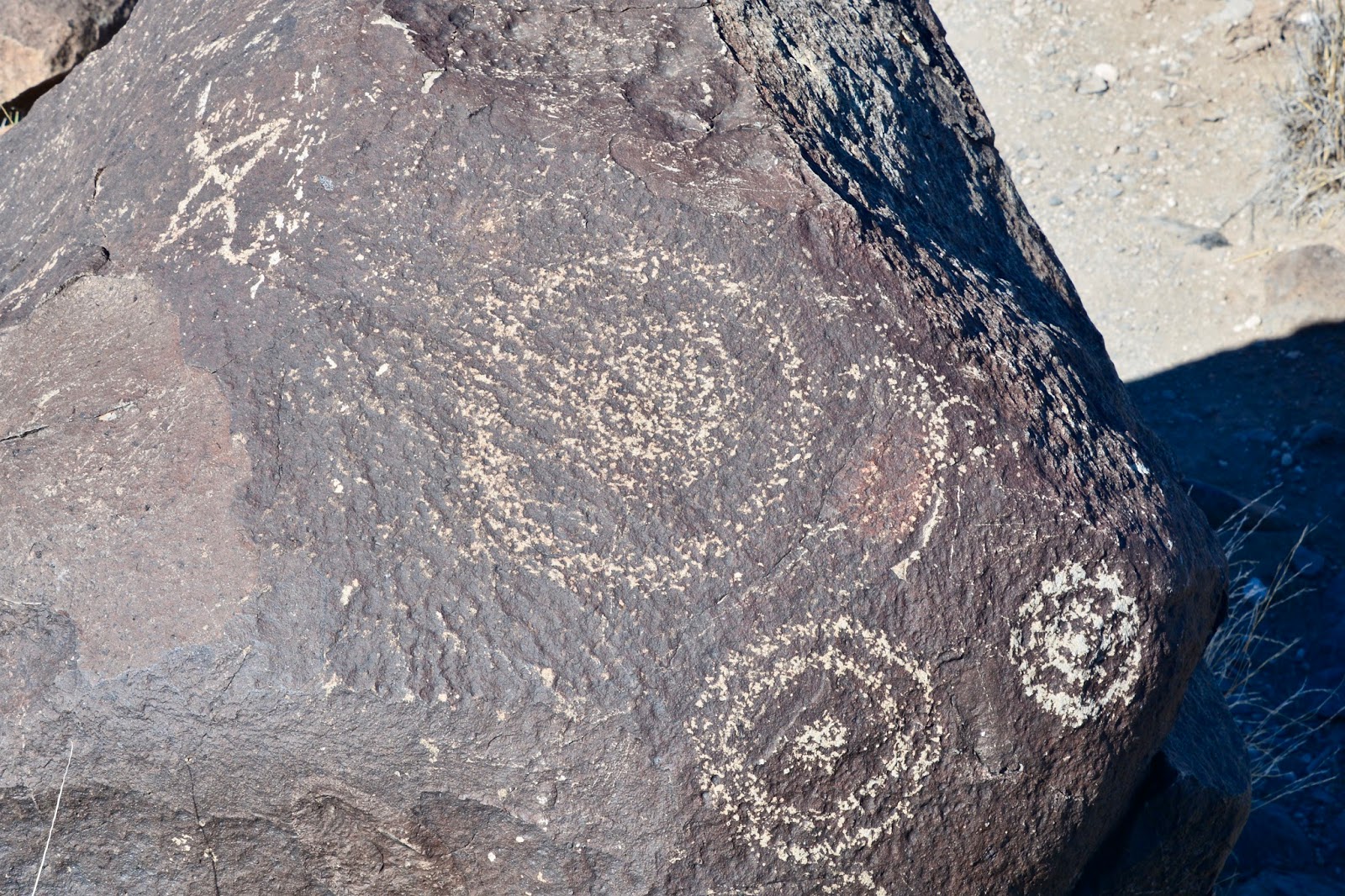
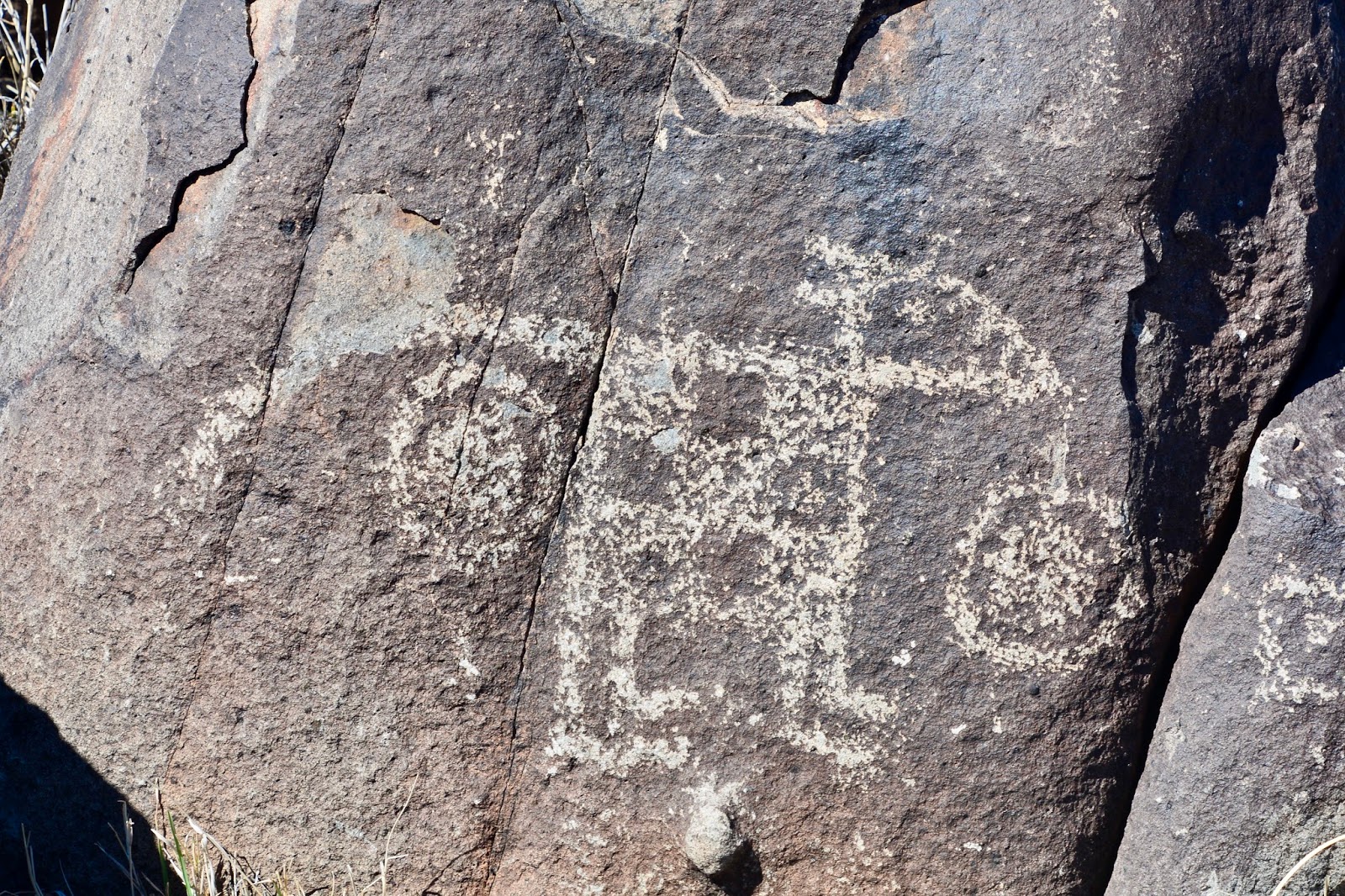
The trail climbs up onto a rocky basalt ridge with the ancient carvings dotting the dark rock, showing geometric patterns, masks, animals, hand prints, and other subjects carved 600-years-ago. Although archaeologists believe that a group of prehistoric Indians known as the Jornada Morgollon carved the petroglyphs, they are uncertain why they were made and what they mean. Researchers believe that the inhabitants of a nearby village on the the banks of Three Rivers Creek carved them during the 400 years that the village was occupied.

The Jornada Mogollon farmed here about a thousand years ago. These people lived in southwestern New Mexico but mysteriously disappeared from the Southwest. While researchers cannot be certain, they believe that war, drought, social decay, depletion of natural resources, or some combination of these factors led to the Mogollon people's disappearance.

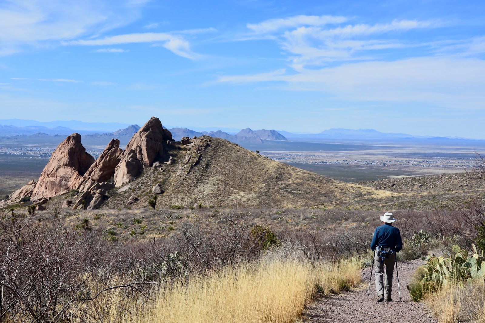
Sierra Blanca, elevation 11,973 ft., dominates this end of the Tularosa Basin and I think I mis-identified this mountain as Cloudcroft in an earlier blog. 

We really enjoyed hiking this basalt ridge and finding the petroglyphs. Following are some of our favorites; be sure to click on them to enlarge the picture to see the details.


Circles are a favorite motif.

This motif showed up more than once.


This was the most complex carving that we saw.


This one looked like an owl to us.

And this one like a road-runner.

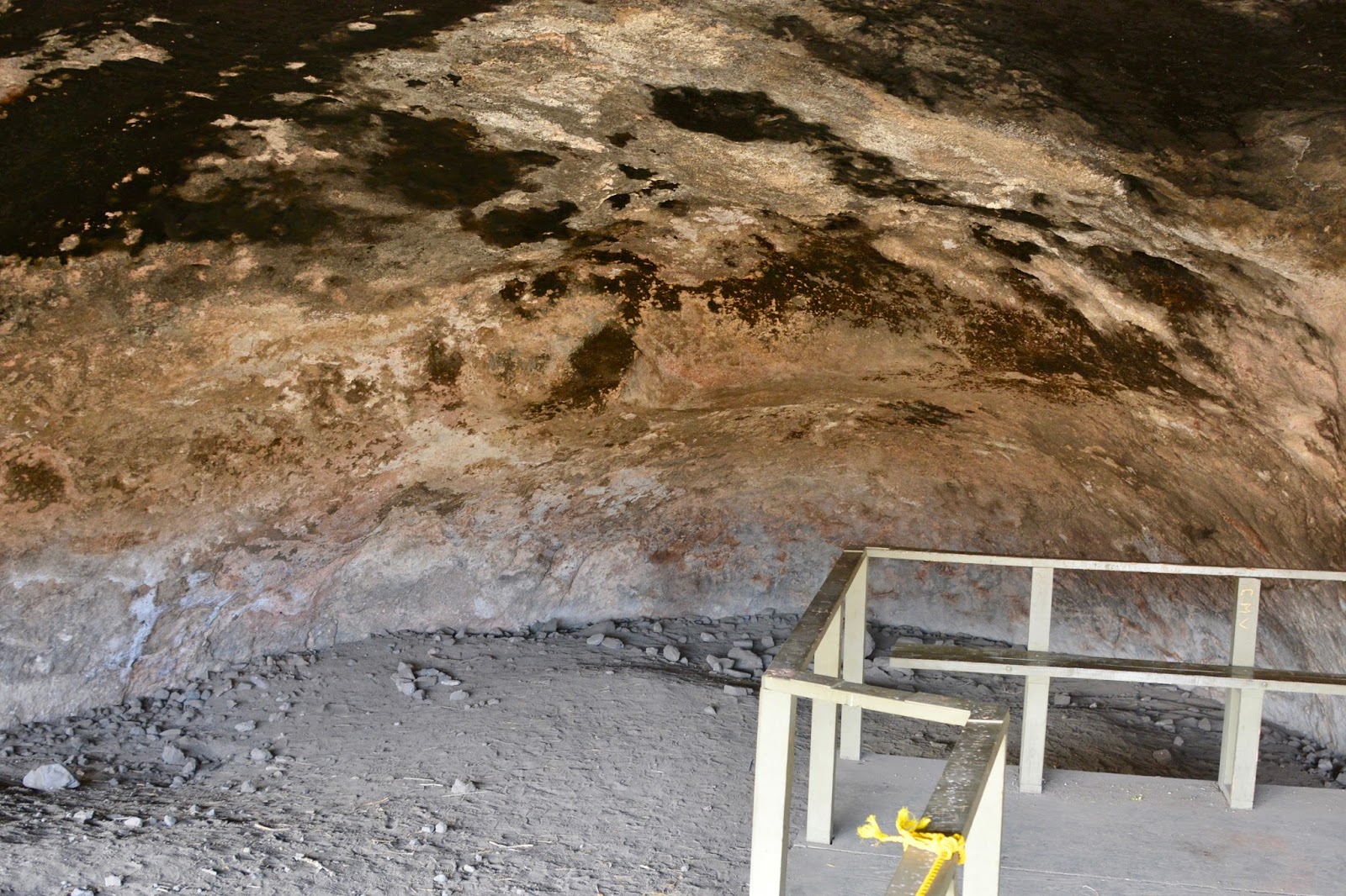
After the petroglyph trail we hiked out to the Mogollon village that was established 1,000 years ago. In the oldest part of the village, people lived in pit houses like this reconstructed one. The people who lived in houses like this were farmers. They raised corn, beans, and squash to go with the wild foods they collected, and depended on hunting for their meat supply.

This partially restored building was built at a later time and is more complex. The floor was cut into gypsum. The roof was built of logs, branches and mud. The hole in the north end of the room, where Frederick is standing, is a storage bin where corn or other plant foods were kept. 

By 1200 AD this was an important village. The people living here traded with others throughout the Southwest and Mexico The village reached its greatest size and influence by 1300 AD, and declined after that. By 1400 AD the village was abandoned. 

Finally, since we are leaving Oliver Lee Memorial State Park tomorrow we thought we should visit the spring that gives this land its importance. The remains of Oliver Lee's flume that brought water to his ranch can be seen at center right.

At the edge of the creek, a little further down from the spring, is the remains of Frenchy's cabin, the first European to farm this land and use the spring for irrigation.

Today's combined hiking:
Length - 2.62 miles
Duration - 2 hours, 30 minutes
Elevation gain - 260 feet (39 floors on the Fitbit)