Tuesday, May 31, 2016

Settling in

It was thirty-two degrees this morning, when we woke up, but the sun was shining and the pine trees were deep green against a clear blue sky when we looked up and out through our bedroom windows. In no time at all the sun had warmed things up and we were able to go out and wash two thousand + miles of dirt and grime off the car and the Airstream. Towing in the rain, as we did most of our trip out west, really puts the grime from the highways on the vehicles. But, now they are both sparkling clean!

View of our site with Frederick putting away the hose after the cleaning.

The campground seems about half full. We are in the first row so there is no one on our curb side and we are the last site in the row so there will be no one in front of us. I love our site!

View out the kitchen window and as you set outside the door. Pretty spectacular!!

Monday, May 30, 2016

Banff on fumes

We've made it to Banff - our home for the next 4 weeks. We hear that back east there have been some 90 degree days, with humidity. Not here; we are still wearing our winter jackets for temperatures that are in the upper 40s and low 50s. The sun was with us a good part of the day and that feels very warm. It's still spring and I'm sure with the coming of summer we'll soon be able to wear shorts.

The drive from Redstreak Campground in Kootenay was short and spectacular. What a great way to enter the Canadian Rockies.

Our welcome into Kootenay National Park. Notice the mountain goat sticking his heard out to the right of the sign.

The pass from the entrance to the hot springs.

The main parking area for the hot springs was fairly full, but not the overflow lots. They were empty.

The red rock that give Redstreak its name.

Kootenay National Park

More Keetenay


In our haste to get to Banff, we neglected to fill up with fuel in Radium Hot Springs and we missed the road sign that said - Gas in 143 km. Fortunately, the route to Banff was downhill and we were able to conserve on fuel. Never-the-less, the last 20 miles we drove with the low fuel warning light on and a message that kept coming up that told us we were low on fuel, did we want to look for a gas station?

Just about to leave British Columbia and...

be welcomed to Alberta and Banff National Park. The park boundary is right at the Provincial border.

Descending into the Bow Valley of Banff National Park with...

plenty of snow-covered mountains.

A road crossing for wildlife. 

Mt. Rundle with Banff at it's base.

We arrived at the Tunnel Mountain Trailer Court and site #111. This fellow supervised our settling in.

Sunday, May 29, 2016

Rivers and rails

We've returned to Canada and one of the first things that we noticed is that there are usually rivers or railroads, or both, that appear alongside the roads. Rivers and rails - it's so Canadian!

We got a very late start for a long towing day, 250 miles, due to a late package pick-up at Marlene's house. That's the thing about full-timing, we are always on the look-out for an address where we can have packages sent for things from Amazon, usually, or King Arthur Flour or Frontier Soups. We really appreciate family and friends who are willing to be our post office!

Despite the late start it was a fun drive up the Panhandle of Idaho and into Canada. We have taken this trip a number of times and it's always fun to see old familiar landmarks.

Lake Pend Oreille

A beautiful farm outside Bonners Ferry.

The road north to Canada.

Canadian Customs. This morning on the Airforums (a site where Airstream owners can discuss anything from full-timing, plumbing & electrical issues, tow vehicles [a perennial favorite], and on-the-road-experiences) someone wrote about their awful experience at the Canadian border being grilled and harassed by Customs' Officials. That got me all nervous about the border crossing, but true to our experience at every one of our crossings into Canada, we were asked a few questions - alcohol or tobacco? firearms? - and then told to have a nice trip. The folks on the Airforums rant had had their apples confiscated. Yesterday we had bought 2 dozen lovely Fugi apples at Costco in Coeur d'Alene and I'm so relieved we didn't lose them!

Picture while we were waiting our turn to go through Customs.

We are delighted to be back in Canada!

As we headed north into Canada, the mountains go bigger and...

BIGGER!

For those "in the know", here's the source of a favorite family saying.

We passed through Fairmont Hot Springs, which is a town that is one big golf course resort in the shadow of the Canadian Rockies.

Soon thereafter, we started up the hill to the Redstreak Campground in Kootenay National Park and...

passed the resident herd of big horned sheep. It's going on 10 o'clock and it's still light out. We're glad to be here!!

Friday, May 27, 2016

Big Sky and two passes

We completed our trip through Montana today and arrived in Idaho late this afternoon.We towed over 300 miles and crossed two passes - Lookout Pass at the Montana/Idaho border and 4th of July Pass just to the east of Coeur d'Alene, Idaho. Tomorrow we will be visiting our daughter Marlene and our three grand kids - Elizabeth, James & Thomas. It will be so good to be with family for the next two days.

Butte was beautiful when we left this morning.

Not too far down the road is Anaconda and shown on the Montana map is the Anaconda Smoke Stake. See it right in the middle at the bottom of the picture?It might not look like much in the picture, but it was BIG when viewed from the road. I guess there's a lot of mining going on around here.

This western part of Montana is beautiful with mountains, steep and rolling hills and lots of trees. Everything is nice and green, too. Springtime!

Much of the way the Clark Fork River was just beside I-90. It got wider and wilder as we drove northwest before it flowed north of the highway at St. Regis, Montana.

After climbing Lookout Pass in Montana we reached the Idaho border and headed down the pass to Wallace and Kellogg, Idaho. You can practically coast across Idaho heading westward through the panhandle.

Late this afternoon we reached Coeur d'Alene. Oh, the memories!! And all good ones, too!!

Paying a visit to the Lake.

Wednesday, May 25, 2016

On the move

We left Grand Teton National Park this morning - in the cold and rain. Despite the sometimes dreary weather our week+ in the Tetons was entirely satisfying. We had some great hiking and the scenery was inspiring.

We just left the park and began climbing on the John D. Rockefeller, Jr. Memorial Parkway toward Yellowstone when we hit the snow line. The temperature outside was 41 degrees when we left the campground, but started to fall as we approached Yellowstone, 8 miles north, but considerably higher in elevation.

It was beautiful, though, and the roads were clear.

Entering Yellowstone National Park through the South Entrance.

As we headed north, towards Old Faithful, it got colder and there was more snow on the ground. Around the Continental Divide it was 35 degrees and there were a couple of inches of snow on the ground and slush on the road.

But, by the time we arrived at the Old Faithful thermal areas, the sun was out, the snow was gone and ...

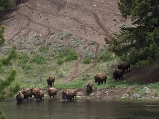
the bison were on the move. This classic-looking guy was strolling along the road just north of Old Faithful.

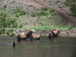
On the road to West Yellowstone there were a few vehicles stopped by the side of the road and when we arrived we saw this herd coming down the hill...

enter the water...

and begin to swim across the Madison River. They crossed the river and then came up and across the road righting front of our car. It was a great scene to watch!

We left Yellowstone just after noon and travelled 88 miles up the Gallatin Canyon to Bozeman and I-90. Shortly after leaving Yellowstone the sun came out and the temperature began to climb, reaching 71 degrees as we travelled I-90 to Butte, where we are staying this evening. I believe that these gorgeous mountains are the Bridger Range just north of Bozeman.

Tuesday, May 24, 2016

Another gem, Phelps Lake Loop Trail

Phelps Lake is located in the Laurance S. Rockefeller Preserve, a section of Grand Teton National Park that was only added in 2001 with a final donation of 3,100 acres of what was once the JY Ranch that the Rockefeller family used for a summer retreat. At the time of his land donation, Laurance removed all ranch structures, including the dining hall and residential cabins. And this part I really like, his donation included an endowment to fund the LSR Preserve Center and the Preserve trails and environment.
Even though the skies were threatening, we looked at the weather time-line and it said that rain wouldn't begin until after 4 p.m. We began by following Lake Creek Trail the first 1.5 miles. 

We reached the lake at 1.5 miles and there, at the overlook on the north edge of Phelps Lake we encountered our lunch buddy from last year. Unfortunately, we had already eaten our lunch - we wouldn't feed a wild animal anyway. 

From the overlook at the north end of the lake, are views across the lake to the south edge with the towering Teton peaks forming a dramatic backdrop at the mouth of Death Canyon. (You might notice Frederick's emergency rain poncho - his rain jacket was safe, back in the Airstream.)

After admiring the vistas at the overlook we continued on the lakeshore path for 0.5 miles to a short spur-trail to Huckleberry Point, a peninsula jutting out into the lake, for some more fine lake and mountain views.

Back on the Phelps Lake Trail we met the cousin to the marmot at String Lake.

At the south end of the lake, at the base of the mountains, is this lovely meadow. You might be able to just make out the inlet stream from Death Canyon that feeds Phelps Lake (center left, by the small trees).

And here's the source of the inlet stream - high up on the mountainside you just might be able to make out the cascade coming off the mountain. (You can always click on the picture and it will enlarge for a better view.)

I liked the way the mountain peaks - seen through the clouds - are mimicked by the Douglas Firs.

At last, some wildflowers!

Today's hike:
Length - 7.08 miles
Duration - 3 hours, 6 minutes
Elevation gain - 660 feet (66 floors on the Fitbit)