Pictures from today's drive, courtesy of Frederick.
When we passed through Rozet on our way to I-90, we passed this establishment that offered Bud Light through a drive-up window and the door to the place was through the back of the chuck-wagon painted on the side of the building. How western!
Frederick was able to photograph some prong-horned antelope. (We enlarged the picture to bring them into view.)
Interesting roadside features as we drove east in Wyoming.
This "plane" served as the wind-sock at a local airport.
Welcome to our "home" state of South Dakota! As most of you know, we are legal residents of South Dakota, so it was a homecoming, of sorts.
Here's our "home" building, in Box Elder, South Dakota, on the outskirts of Rapid City. We stopped to pick up our mail and say, Hi! There's a nice Flying J fuel stop just next door.
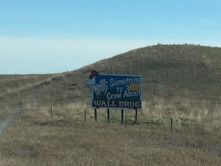
As soon as we left Box Elder we were deluged with Wall Drug signs. Here are just 5 of the 20, or so, pictures that Frederick took. And that was just a sampling of the hundreds (seemingly) of signs that appear along I-90.
Frederick's daily cloud picture.
Our lunch stop at a rest stop in South Dakota. All the rest stops have a teepee frame.
The Badlands to the south. Those are probably Wall Drug signs along the side of the road.
Some more prong-horn antelope, enlarged. We saw quite a few today, but not nearly the number we saw yesterday in Wyoming.
We also began to see signs of agriculture. Hay rolls in the field and some fields of harvested corn.
Driving through central So. Dakota, this popped-up on our gps. The community of Vivian.
The community is just a small gathering of buildings on the open plains.
Right about this time we entered the Central Time Zone and "lost" an hour.
This is a harvested field of sunflowers. There were quite a few of these fields.
All of a sudden, the flat plains begin to have some texture as we approach the Missouri River.
Crossing the Missouri River about 6 o'clock.
The campground where we are staying tonight is in Chamberlain, right along the banks of the Missouri River.


No comments:
Post a Comment