Grand Canyon of Texas
“Palo Duro” is Spanish for “hard wood” in reference to the Rocky Mountain Juniper trees still seen in places in the canyon. Texas’ second-largest park, Palo Duro Canyon is 120 miles long and 800 feet deep, and is the second-largest canyon in the United States.
The canyon was formed less than 1 million years ago when the Prairie Dog Town Fork of the Red River (I think this must be the longest river name in the U.S.) first carved its way through the High Plains of the Texas Panhandle. The rocks expose a geologic story which began approximately 250 million years ago. Some of the oldest rock layers in the canyon belong to the Triassic Period. These rocks, which are located at the bottom of the canyon, are noted for their bright red claystone and white gypsum. Next, rocks from the Jurassic Period can be seen with their yellow, gray and lavender mudstone. The sandstone and coarse gravel of the Cretaceous Period can be seen as you further ascend the canyon. The next layer of rock are from the Ogallala Formation (about 5 million years ago) with sand, silt, clay and limestone.
We left Caprock Canyon State Park this morning and drove the 90 miles to Palo Duro, which is about 20 miles south of Amarillo. Caprock was smaller, shallower and more intimate and we liked hiking right up against the canyons. Palo Duro is more dramatic and three times as deep. We have driven over the edge of the Canyon and are now camped on the bottom, eight miles from the Headquarters Building that is located up on the rim.

Our incredible campsite at the bottom of the canyon.

Caprock had the Texas bison herd, Palo Duro has the Texas longhorn cattle herd.

After setting up we went off to find a couple of short hikes to get some exercise. Paseo Del Rio (2 miles, rated easy) was our first trail.

Most Texas state parks have numerous warnings to drink plenty of water and to bring at least one quart of water per person per mile. This is primarily in the summer time when I guess it gets mighty hot in the canyons. However, this is the first park where there is a thermometer at the beginning of the trails to drive home the fact that it does get extremely hot. You might be able to see that the thermometer reads 70 degrees. This was at 5:30 p.m.
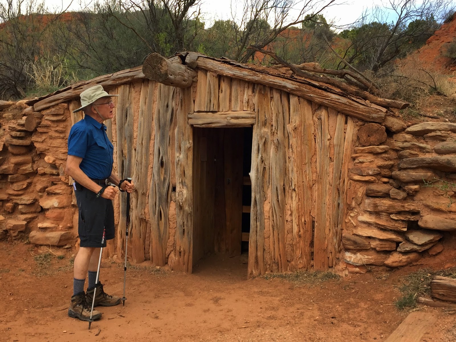
Along the Paseo Del Rio Trail there is a Cowboy Dugout which is typical of the way cowboys lived in the 1880s.

Built into the hill, it must have been relatively cool in the summer and easy to heat in the winter.
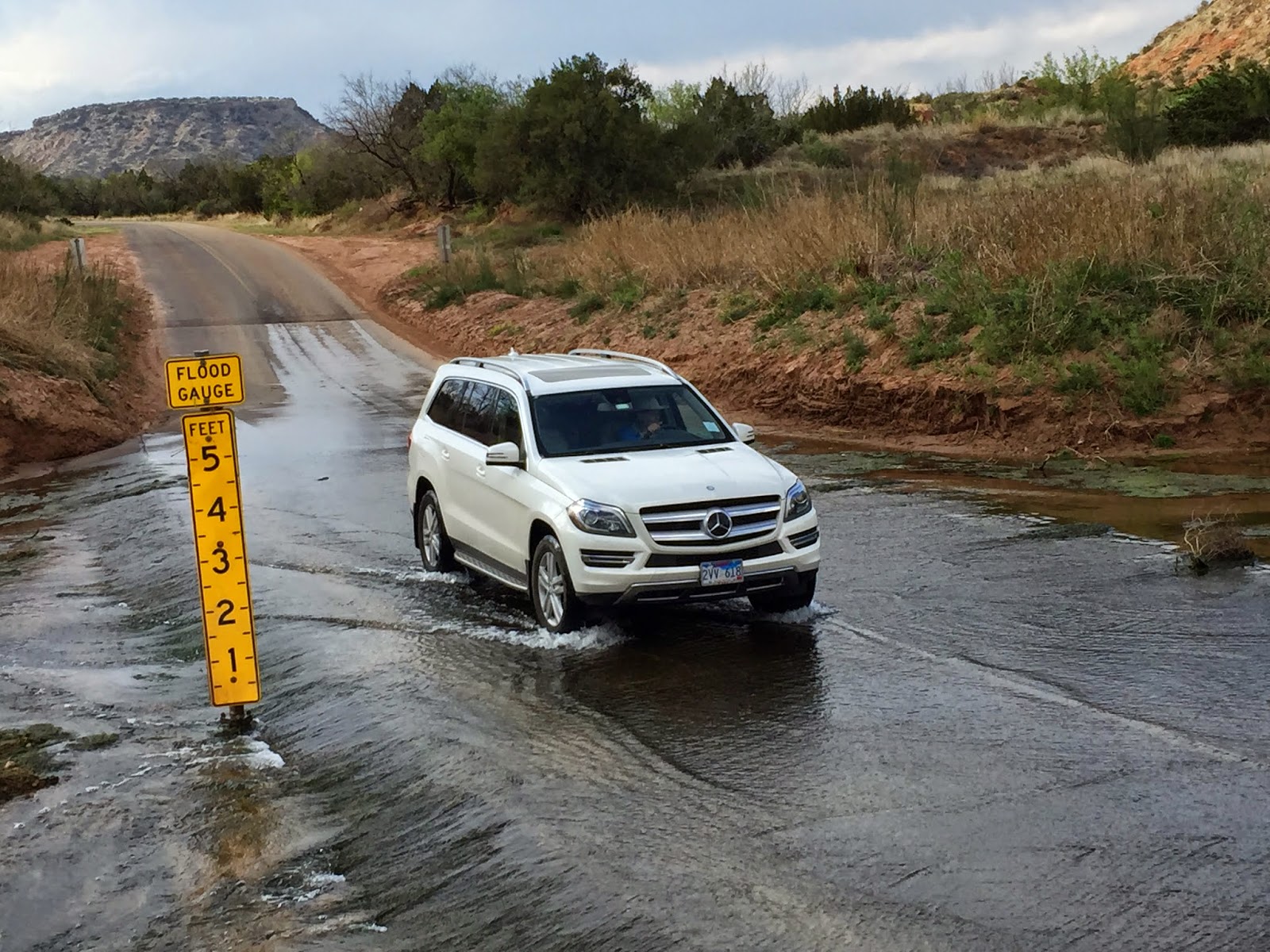
This is the most adventurous park we have been to in Texas. In addition to driving down into the Canyon on a 10% grade road for two miles, there are 6 river crossings where the road is under water. The park brochure warns of flash flooding and not to cross the water if the depth gauges at the crossing shows water in excess of six inches. (Frederick got out and took this picture as I drove across.)

We next took the Sunflower Trail ( 2.3 miles, rated easy). The Sunflower Trail was more shady and took us closer to the canyon walls.

We were also fortunate to see a “threatened” Texas horned lizard. Frederick first saw it on the trail, which was a good thing because it is extremely well camouflaged in the grass along the side of the trail.

There was a kind of viewpoint along the trail. This is looking northeast.

And this is looking southeast. The canyon valley is beginning to get dark.

The sides of the cliffs are almost rainbow hued.

This stream, which joins the river, is clear and this spot along the trail was tranquil and green.
Another group of stunning blog pictures. Thank you for the updates.
ReplyDelete