On the way we stopped at Arkansas Post National Memorial, a park operated by the National Park Service, that was the site of the first European settlement in the lower Mississippi River Valley.

Outside the Visitor Center entrance, the six different flags that have flown over Arkansas Post are displayed. The French were the original Europeans to establish a trading post (hence the name, Arkansas Post) in 1686. In 1763 France ceded its lands west of the Mississippi to Spain (2) but in 1801, Spain returns the Louisiana territory, including Arkansas, back to Napoleonic France (3). Of course, in 1803 the United States purchases the Louisiana Territory (4) but during the Civil War Arkansas became part of the Confederate States of America (5). After a victory by the Federals against the Confederates in 1863, the town of Arkansas Post returned to the Stars and Stripes (6).

Arkansas joined the Southern Confederacy on May 6, 1861. The following year a fort was built at Arkansas Post to control the Arkansas River, the North's most feasible route of invasion. This garrison, called Ft. Hindman, consisted of about 5000 men.

On January 10, 1863, Union Major General John A. McClernand arrived with nine gunboats and 30,000 men. Unable to withstand the heavy bombardment and land assaults that followed, the Confederate forces surrendered to the Union after a bloody 2-day battle. At this battle, Major General William Tecumseh Sherman was a Corp Commander under McClernand. Sherman is thought to be responsible for most of the planning and implementation of the land assault on Arkansas Post.

The parking lot. The other car belongs to the one staff person at the Visitor Center.

There was a walking tour of the remains of the town and fort which are mainly the foundations. But at one time, this spot was a thriving town of 1,000 people.

If you look carefully you can see a deer lying down at left center and one standing looking at us right in the middle of the picture. There is a small body of water on the tour where we were told we might see one of the 5 15-foot alligators. We didn't see any.

We did see mistletoe in some of the trees.

We also saw this tree with large, softball-sized chartreuse balls beneath it. When we asked in the Visitor Center we were told this is the largest Osage Orange tree in Arkansas.

Some fruit still remaining on the tree.

Some of the fruit had rolled down into the rifle pits that honeycomb the grounds.

During the American Revolution, Arkansas Post belonged to the Spanish, allies of the American patriots. In 1783, British partisans led by James Colbert raided the Spanish village and fort here. It was one of the last engagements of the war, and the only one Arkansas.
Our next stop was at what is considered one of the most significant archaeological sites in North America - Poverty Point State Historic Site in Pioneer, Louisiana. Named for the southern plantation located nearby, Poverty Point is a huge complex of 6 mounds, 6 semi-circular ridges, and a plaza. The largest mound is about 70 feet tall and more than 700 by 640 feet at its base. At the time Poverty Point was built (about 1500 BC), its earthworks were the largest in the Western Hemisphere. Some archaeologists believe that the large mound is an effigy mound built in the shape of a bird. In a video we saw at the Museum/Visitor Center, the bird shape was visible when looked at from about 1000 feet above. The function of the mounds is unknown, but they were not used for burials.

This is an arial view painting that imagines what the site looked like. The outermost ridge is .75 mile in diameter, and all of the ridges laid end-to-end would stretch 7.5 miles. You can also see the large effigy mound at the top of the concentric ridges and the large, 35 acre, plaza in the middle.
The ridges served as living surfaces; archaeologists have found postholes, pits, hearths, earth ovens, and domestic debris in and on them. Construction of all the earthen mounds and ridges required about 981,000 cubic yards of dirt. Investigation also has shown that the builders filled in low areas and gullies to create the level plaza.

View of the large effigy mound, Mound A, from the Museum. We were able to get in the car and drive around the immense site.

Mound A, is the largest earth-moving project built by the ancient inhabitants and is also considered as the largest mound built in the Western Hemisphere at its construction - around 1400 B.C. It has a volume of 90,000 tons of dirt that was carried in baskets. It would have taken 4.5 million 40-pound basket loads of soil to complete this project.

This is Mound B. Charcoal from this mound yielded a carbon-14 date of approximately 1600 B.C. Its purpose is not known.

I know they don't show up in the picture above and below, but these raised areas are the remains of the ridged embankments. If you combined all of the ridged embankments at Poverty Point, there would be seven and a half miles of living area. If you placed a structure every 50 feet, this would give a total of 744 houses, indicating a large population inhabiting this site.


These are some of the figurines found at Poverty Point. Only 16 are whole, most of them have their heads broken off.
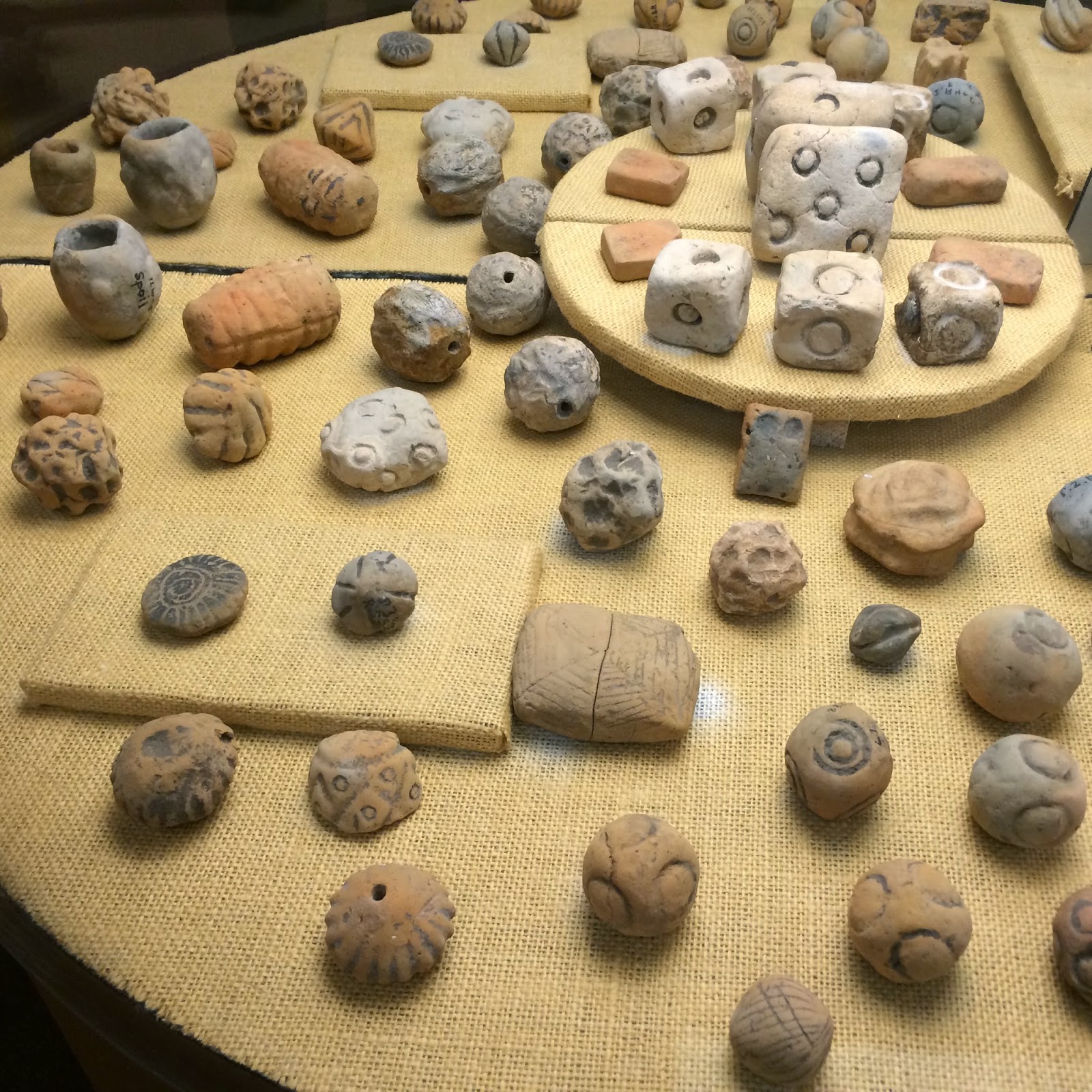
These objects represent an experiment with beauty and design. Some objects show images and shapes, like cubes, spheres, circles, zigzags, grids and spirals. This suggests that these people were developing an affinity for abstract thought. Also, some objects depict natural things, which would have been extremely common such as a spider web, owl, and lotus pod.

Over 8000 whole spear points have been found at the site. This implies that hunting was extremely important to this culture. These stone points came in a variety of shapes, sizes and materials. Due to the lack of local flint, these people must have developed an exchange system to bring this material from hundreds of miles away.

The Poverty Point people had an extensive trade network, as indicated by raw materials from Arkansas and Mississippi, the southern Appalachians, and the Ohio and upper Mississippi River valleys; these materials were likely transported via watercraft.


These engraved objects have parallel lines, cross hatch designs, the figure eight, and birds adorn some objects. The most complex engraving is the "Foxman". It appears on several different objects and in separate village sites.
The people of Poverty Point did not practice agriculture; they were fisher-hunter-gatherers. They did not eat maize, but subsisted mainly on nuts and acorns, aquatic roots (lotus, cattail), fish, deer, small mammals, and turtles.
New research has indicated that a climatic change may have caused severe flooding in the lower Mississippi Valley giving a clue to why the thriving Poverty Point center may have been abandoned around 1100 B.C. This would have been catastrophic to a people that depended on this flood-plain environment for most of the food that sustained the Poverty Point people for so long. Major mound construction ground to a halt until about a thousand years later .
I'm curious, how cold is it there? Did you get far enough south or are you frozen, too? The mounds are interesting, they must serve some purpose, that's a lot of dirt to move on a whim.
ReplyDeleteThe history of the Arkansas Post National Memorial is amazing. Who would have thought there would be such a storied history in the area, with 7 different flags flying until it was returned to the U.S. The Poverty Point State Historic Site with the prehistoric time frame and 6 mounds sounds fascinating. Your description and photos make it all so real for those of us reading your blog. Thanks, Judy S.
ReplyDeleteThanks for all the pictures. I read about the Poverty Point Site in grad school and really enjoyed seeing the mounds and artifacts. I get a good sense of the complexity of these early cultures by seeing these surviving ruins. Amazing stonework in the projectile points. Bill
ReplyDelete