Kejimkujik National Park is at the center of the Kejimkujik Drive which follows a series of rivers and lakes. It begins on the north shore at Annapolis Royal and ends on the south shore at Liverpool, on the way to Halifax. The Mi'kmaq, traveling in canoes, used the rivers and lakes as a "highway" for more than 1,000 years. Kejimkujik Lake, the park's namesake and largest lake, has many hidden coves and islands. Hundreds of years before the arrival of the first Europeans in Canada, this lake and its surroundings were the home of nomadic Mi'kmaq people. Even though we were towing, we stopped at the Kejimkujik Visitor Center after leaving Annapolis Royal and heading towards Halifax.
Kejimkujik is the first National Park of Canada to be recognized also as a National Historic Site and acknowledges that the Kejimkujik area is "a cultural landscape of the Mi'kmaw nation" and that "the Mi'Kmaq have occupied this area since time immemorial". Its importance to the Mi'kmaq is based on millennia of ancestral history. The earliest traces of ancestors of today's Mi'kmaq date back more than 10,000 years. They came into the Maritimes at the end of the last great ice age, when retreating glaciers revealed an inviting land. Sometime thereafter, they arrived in the southwestern area of Nova Scotiia, known to the Mi'kmaq as Kespukwitk or "Land Ends." They moved between areas according to the cycle of the seasons and the availability of food sources.
With an abundance of caribou (no longer on Nova Scotia), moose, freshwater fish and other staples, the Kejimkujik area made an ideal living site for the fall and winter months. Spring and summer seasons were spent at the coasts gathering saltwater fish. The Mi'kmaq used the system of rivers and lakes to travel and Kejimkujik was a regular stop. The Mi'kmaq left little imprint on the land but research has uncovered the remains of seasonal camps, burial grounds, fish weirs, portages and trails. Over 60 sites have been identified in this area dating back between the Late Archaic and Colonial periods.
The most noticeable traces left by the early Mi'kmaq are the engravings cut in the glacially polished slate outcrops along the lake shores. Referred to as petroglyphs, there are over 500 individual petroglyphs within Kejimkujik National Historic Site, making it the largest collection of such images in eastern North America. Some images portray men and women wearing traditional clothing. Over 60 petroglyphs depict the unique peaked hat worn by women which suggests the importance of women in Mi'kmaw society.
The distinctive sea-going canoe of the Mi'kmaq - built with raised sides, and often rigged with a small sail - is seen in several petroglyphs. Other petroglyphs are signatures in script. While the Mi'kmaw culture was primarily oral, elders tell of a seldom-used written language. We were not able to travel to the parts of the park that had the petroglyphs but we were able to view pictures in a book at the Visitor Center.
Bill Simmons alert!!!
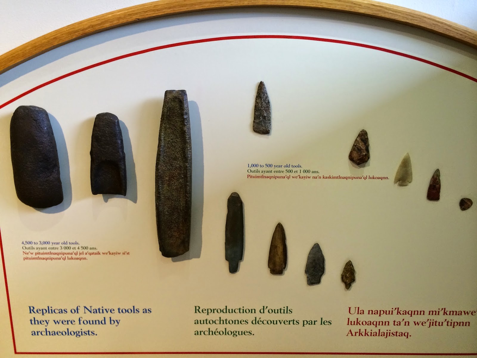
The first three objects above date from 4,500 to 3,000 years ago. The remaining are from 1,000 to 500 years ago.

How the complete tool appeared when it was in use.
After spending time in the Visitor Center we took a short hike.

This single tree had six trunks.

Partway along the trail we came to the highest (!!) falls in the park, Mills Falls (because at one point a man built a mill at the falls). There was also a descriptive sign that talked about why the water is brown and there is so much foam. This is the Mersey River and its brown water is called Mersey tea. Water, seeping through bogs, is stained by organic compounds. The bogs add naturally occurring organic substances to the water. Tannins stain the water brown and saponins are like natural soaps; when they fall over a waterfall they form stable foam.

A little further down the trail we stopped to have our lunch near some rapids.

I think we are getting better at taking selfies. Frederick hods the camera out, since he has long arms, and I push the button.
We are now tucked in our site at the Rayport Campground on the Martins River in Mahone Bay. When we arrived we learned that this family campground was celebrating Halloween, in August. There were Halloween decorations all through the park and there was trick-or-treating from 6:30 - 7:30 pm. We felt terrible that we did not have any candy to hand out. Fortunately, those RVs that were prepared to give out candy were supposed to post a jack-o-lantern picture on their RV so, at least, no one came to our door. We felt a little like Scrooge, but we enjoyed seeing the little kids in their costumes.

Decorations at one campsite covered more than one site.

This was the entrance to the office when we arrived. Our first clue that something interesting was happening.

Other campsite decorations. The cat moved its head from side-to-side.

Our site backs right up to Martins River. (I have more pictures but the internet is not good so they'll have to wait.)
Kejimkumik was a magnificent experience!
ReplyDeleteFrederick
Hi again.
ReplyDeleteThis comment has been removed by the author.
ReplyDeleteI love the selfies. They are very good!! Dale you look like a new woman. It's amazing how stress affected you, of course Fred is his dapper self:)
ReplyDelete