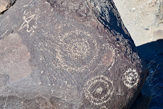
The trail climbs up onto a rocky basalt ridge with the ancient carvings dotting the dark rock, showing geometric patterns, masks, animals, hand prints, and other subjects carved 600-years-ago. Although archaeologists believe that a group of prehistoric Indians known as the Jornada Morgollon carved the petroglyphs, they are uncertain why they were made and what they mean. Researchers believe that the inhabitants of a nearby village on the the banks of Three Rivers Creek carved them during the 400 years that the village was occupied.
The Jornada Mogollon farmed here about a thousand years ago. These people lived in southwestern New Mexico but mysteriously disappeared from the Southwest. While researchers cannot be certain, they believe that war, drought, social decay, depletion of natural resources, or some combination of these factors led to the Mogollon people's disappearance.
Sierra Blanca, elevation 11,973 ft., dominates this end of the Tularosa Basin and I think I mis-identified this mountain as Cloudcroft in an earlier blog.
We really enjoyed hiking this basalt ridge and finding the petroglyphs. Following are some of our favorites; be sure to click on them to enlarge the picture to see the details.
Circles are a favorite motif.
This motif showed up more than once.
This was the most complex carving that we saw.
This one looked like an owl to us.
And this one like a road-runner.
After the petroglyph trail we hiked out to the Mogollon village that was established 1,000 years ago. In the oldest part of the village, people lived in pit houses like this reconstructed one. The people who lived in houses like this were farmers. They raised corn, beans, and squash to go with the wild foods they collected, and depended on hunting for their meat supply.
This partially restored building was built at a later time and is more complex. The floor was cut into gypsum. The roof was built of logs, branches and mud. The hole in the north end of the room, where Frederick is standing, is a storage bin where corn or other plant foods were kept.
By 1200 AD this was an important village. The people living here traded with others throughout the Southwest and Mexico The village reached its greatest size and influence by 1300 AD, and declined after that. By 1400 AD the village was abandoned.
Finally, since we are leaving Oliver Lee Memorial State Park tomorrow we thought we should visit the spring that gives this land its importance. The remains of Oliver Lee's flume that brought water to his ranch can be seen at center right.
At the edge of the creek, a little further down from the spring, is the remains of Frenchy's cabin, the first European to farm this land and use the spring for irrigation.
Today's combined hiking:
Length - 2.62 miles
Duration - 2 hours, 30 minutes
Elevation gain - 260 feet (39 floors on the Fitbit)


No comments:
Post a Comment