The road up the mountain. If you look carefully (and enlarge the picture) you might be able to see, bottom center, one of the trestles the railroad used to span the mountain valleys to bring visitors up to Cloudcroft.
We hiked the Osha Trail through the forests of the Sacramento Mountains near Cloudcroft. At first it was great to be hiking through Douglas fir, aspen, and pine again until...
we hit the snow on the back half, the north side, of the loop trail. Many people must have hiked the trail over the holiday weekend because where the snow had been packed down it was more like ice - not good for hiking downhill!
We had some excellent views from the trail of the Tularosa Valley and the White Sands.
When we finished skating our way around the trail we drove 16 miles south of Cloudcroft to the National Solar Observatory at 9,200-ft Sacramento Peak, affectionately known as Sunspot. The Visitor's Center is closed in February, but there is a self-guiding tour around the grounds. The instrument at the lower left side of the picture is accompanied by a plaque which identifies it as an Armillary Sphere and Sundial. It uses rays from the sun to inform an observer of the current date and time. (Only during daylight hours)
While we were beginning our tour and looking at the Katie and her dog, Andromeda, came by and we started to chat. She's a telescope operator with a degree in physics from Rensselaer Polytechnic Institute in New York. She has housing at Sunspot and works at the adjacent Apache Point Observatory, working mostly at night.
No longer used as an observatory, the Hilltop Dome was completed in 1963 and rotated around to allow the telescope to see the sun anywhere in the sky. Improved instruments have closed the facility for observations, but the building is now utilized as an instrumentation and optical design laboratory for the future Advanced Technology Solar Telescope (ATST) which will be built on the summit of Haleakala on Maui, Hawaii.
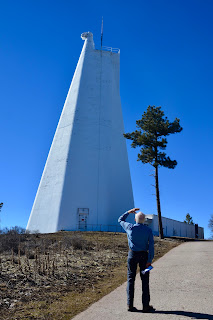
This is the "big guy on campus", the Dunn Solar Telescope, containing an entrance window and two mirrors that guide the light of the Sun down the tower in an evacuated tube from which the air had been removed. The tower is an impressive 136-ft tall, but the building has 228 more feet below ground, so most of the building is not visible. Most of the attached building hold the labs that the scientists use and is closed to the public, but we were able to enter a front reception area that had a wall that lit up with information about the sun.
Next to the Dunn Solar Telescope was a small Visitor observation platform. From there I was able, using the tele-photo leans, to get a picture of the near-by Apache Point Observatory.
Also from the observation platform we could look over the Tularosa Valley, and White Sands. The canyon at the bottom of the picture we believe is Dog Canyon. Looking at the road map, Sunspot appears to be above Dog Canyon in the Sacramento Mountains.
Close-up of what we think is Dog Canyon.
In 1950, the Grain Bin Dome was the first telescope dome built in Sunspot. The Observatory ordered the grain bin from a Sears catalog and modified it for use as a telescope dome.
This dome outside the Visitor's Center represents the sun in the Sunspot Solar System Model. (scale: 1:250 million) Traveling back along the Sunspot Scenic Byway to Cloudcroft, signs representing the planets in our solar system are placed at the correct distance from the sun on that scale. We set the odometer to zero and recorded these distances from this "sun":
Mercury .2 Jupiter 3.2 (Pluto would be someplace in downtown Cloudcroft
Venus .34 Saturn 5.42 but we did not go downtown to find it.)
Earth .57 Uranus 9.65
Mars .88 Neptune 14.85
Today's hike:
Length - 2.63 miles
Duration - 1 hour, 27 minutes
Elevation gain - 580 feet, 58 floors on the Fitbit)


Nathan would love the "sun" and the telescopes. How interesting.
ReplyDelete