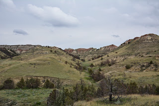
Today's introductory hike was the Jones Creek (how could we resist) Trail that bisects the scenic loop road and presents a cross-section of the terrain in the Southern Unit of the Park.
Trail markers along the way.
This is Jones Creek, a deeply eroded creek bed that is just about dried-up after the spring thaw and run-off.
More pictures from the trail -
After the hike we continued in the car along the scenic loop road.
Our next stop was at the Boicourt Overlook. From a high plateau we were able to look over the broken badlands.
There was a short, 1/2 mile, trail that took us out on a promontory for one of the best views of the badlands in the park.
Another short nature trail is the Coal Vein Trail. From 1951 until early 1977 a fire burned here in a coal seam. The intense heat baked the adjacent clay and sand, greatly altering the appearance of the terrain and disturbing the vegetation. Burning coal veins have helped shape the badlands. Lightning, range fires or spontaneous combustion can ignite coal beds. As a coal seam burns away, the earth above slumps into space once occupied by the coal.
Heat from the coal fire bakes the surrounding clay into natural, red, brick, locally called "scoria."
An old, twisted tree along the Coal Vein Trail.
A narrow coal seam.
Wild horses roam in the South Unit just as they did when Roosevelt rode over this land.
We are charmed by these bowl-shaped formations.
A little bit like a Devils Tower wannabe.
True scoria is volcanic in origin. Locally, where coal seams have caught fire and baked the surrounding sand and clay, the result - like a natural brick - is called scoria. Over the years erosion has removed the softer earth and left the bluffs capped with this harder, more resistant material.


No comments:
Post a Comment