Saturday, October 31, 2015

Don't Thump Your Melon

Happy Halloween!

We are taking a pause in our cross-country journey and staying two nights in Chamberlain, South Dakota, on the banks of the Missouri River. It is also a location that celebrates the Lewis & Clark expedition and we wanted to hike a bit of the Lewis & Clark Trail - which we did today.

The trail, which begins in our campground, then passes through the town of Chamberlain, population 2,387, allowed us to enjoy some of the Halloween decorations.

This black cat moves it's head from side to side. I like that the jack-o-lanterns all have happy faces, as do the "ghosts".

We shared the trail with bicycles and were reminded that, if we were on bicycles, we should wear a helmet. 

On the outskirts of town is St. Joseph's Indian School, a privately funded school and mission for Lakota children. 

At this point on the Missouri the river makes a huge "bend". On September 20, 1804, the Lewis & Clark expedition began its journey around the Big Bend. Although only 1 1/4 mile across the neck of land, the party had to travel 30 miles by water. 

The trail climbed a bluff and we had an expansive view of the river from the top. This is looking south, toward the bend and...


this is looking north. It was here that the expedition killed their first female antelope. Clark notes that "She Differs from the Mail as to Size being Smaller, with Small Horns, Straight with a Small Prong without any black about the Neck. None of these Goats has any Beard, they are all Keenly made and is beautiful."

On the way back to town we walked through the St. Joseph's Indian School Campus which...

is also the location of the Akta Lakota Museum and Cultural Center. Unfortunately we didn't have a lot of time so we just glanced at some of the exhibits.

Friday, October 30, 2015

Visit Wall Drug

It was a long day of towing (335 miles) - and a confession; on those long, empty stretches of road across Wyoming and South Dakota, we did bump up the speed to 65 mph. Not the posted 80 mph, but faster than we have gone before. We could almost feel the extra fuel being sucked up, but maybe we saved about a 1/2 hour of travel time. Towing that fast is not something I want to do very often, but those wide open stretches...

Pictures from today's drive, courtesy of Frederick.

When we passed through Rozet on our way to I-90, we passed this establishment that offered Bud Light through a drive-up window and the door to the place was through the back of the chuck-wagon painted on the side of the building. How western!

Frederick was able to photograph some prong-horned antelope. (We enlarged the picture to bring them into view.)

Interesting roadside features as we drove east in Wyoming.


This "plane" served as the wind-sock at a local airport.


Welcome to our "home" state of South Dakota! As most of you know, we are legal residents of South Dakota, so it was a homecoming, of sorts.

Here's our "home" building, in Box Elder, South Dakota, on the outskirts of Rapid City. We stopped to pick up our mail and say, Hi! There's a nice Flying J fuel stop just next door.

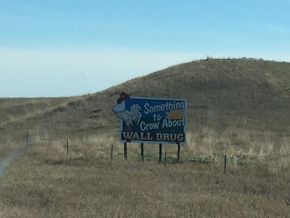
As soon as we left Box Elder we were deluged with Wall Drug signs. Here are just 5 of the 20, or so, pictures that Frederick took. And that was just a sampling of the hundreds (seemingly) of signs that appear along I-90.


Frederick's daily cloud picture.

Our lunch stop at a rest stop in South Dakota. All the rest stops have a teepee frame.

The Badlands to the south. Those are probably Wall Drug signs along the side of the road.


Some more prong-horn antelope, enlarged. We saw quite a few today, but not nearly the number we saw yesterday in Wyoming.

We also began to see signs of agriculture. Hay rolls in the field and some fields of harvested corn.

Driving through central So. Dakota, this popped-up on our gps. The community of Vivian.

The community is just a small gathering of buildings on the open plains.
Right about this time we entered the Central Time Zone and "lost" an hour.

This is a harvested field of sunflowers. There were quite a few of these fields.

All of a sudden, the flat plains begin to have some texture as we approach the Missouri River.

Crossing the Missouri River about 6 o'clock.

The campground where we are staying tonight is in Chamberlain, right along the banks of the Missouri River.


Thursday, October 29, 2015

Where the Antelope Play

We saw a lot of antelope today, only they are fairly small and graze just far enough off the interstate  that Frederick could not get a good picture. We have come 481 miles of our 2,844 trip - a nice dent.  Tonight we are in Rozet, WY, founded in the 1890s and probably named for the wild roses that bloom around here - but not now. The population is just about 1,000 people.

Today's pictures. We could definitely saw the landscape change as we drove from Montana, then into central Wyoming and now we are in northeastern Wyoming.

These green mounds are in Montana.

Driving south towards Wyoming with the Big Horn Mountains in the distance.

Welcome to Wyoming!

The Big Horn Mountains definitely dominate the horizon in north central Wyoming.

As we moved east in Wyoming these mound formations took over the landscape.

Frederick's cloud picture for the day.

Natural gas production in eastern Wyoming.

This landscape reminded me of the badlands in the Dakotas. 


Posted speed limit. We limit our towing speed to 60 mph.

Patriotic eastern Wyoming. Notice the "sipper" in the upper left.


Wednesday, October 28, 2015

Early Start

We left West Yellowstone this morning when the temperature was in the teens. Our original plan was to leave tomorrow, Thursday, but the weather forecast was for snow overnight into Thursday so we decided that it was better to drive out, through the mountains, in clear weather and sunshine. Tonight we are Billings, Montana, at a lovely RV park; lovely because it's open and there are hot showers. The weather forecast is for above freezing temperatures overnight. Yeah!

 Here are some scenes from today's drive, courtesy of Frederick.

 West Side of Yellowstone National Park
The mountains we hiked into on our way to Big Horn Peak (see blog for Saturday, October 24)


Between Yellowstone and Butte


Along Interstate #90, between Butte and Billings


Arriving in Billings