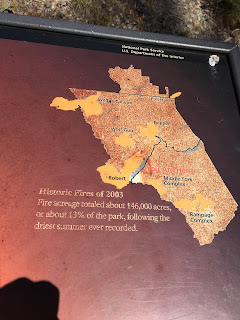
This map of Glacier shows the extent of the 2003 fires in orange. The bulge on the left side, in the center of the park, is the location of the "Robert" fire and where we hiked today. (This map also shows the Going-to-the-Sun-Road cutting through the center of the park and The Loop half-way along the road. See yesterday's blog.)
About 1/2 mile along the trail there is a short spur to Rocky Point and elevated views of the lake and the surrounding mountains.
Nature making use of the burned forest. (Notice the nest in the burned snag - center of the picture.)
Our lunch spot along on the pebble beach.
The main trail winds through the burnt forest. It was hot today, in the mid-80s, maybe the hottest hiking we have done all summer.
We saw plenty of baby aspen trees and...
"pioneer" fir that will compete to become the dominant tree in the new-growth forest.
Baby fir.
A baby larch trying to compete with a pine.
Fir and larch making a come-back.
Baby larch.
Most of the trail looked like this. You can see Lake McDonald through the burned snags.
Near Fish Creek Campground, where the trailhead is, the path marks the burned forest (on the right) from the un-burned (on the left). Back-fires were started to the right of the trail to protect the Fish Creek Campground.
Bridge across Fish Creek.
Lovely Fish Creek... closed to fishing.
Trail statistics -
6.5 miles
Elevation gain: 160 feet; 71 floors on the Fitbit
Duration: 3 hours


No comments:
Post a Comment