Tuesday, August 26, 2014

Glooscap

Today, being a moving day, we were moving on down the road when we saw a sign about a Mi'kmaq Heritage Centre at Millbrook, Nova Scotia. Not too much further along we saw a huge statue of a First Nations man towering over the highway. Hesitating for maybe a second and a half we slowed down and took the exit. There was a huge parking lot across the street so we pulled in, parked the Airstream, and entered the Centre.

What a great place! There was a short video with Glooscap, a mythological person, introducing the Mi'kmaq people, culture and history, bringing their history up to the current time. Glooscap doesn't speak English, so when he spoke in Mi'kmaq there were sub-titles. He frequently introduced anthropologists and elders who spoke in English (with Mi'kmaq sub-titles). Unfortunately, the current history of the Mi'kmaq, from the time of European contact until now, is not that much different than the history of the Native Tribes in the U.S. 

The Mi'kmaq lived in Nova Scotia, Prince Edward Island, New Brunswick, Newfoundland, the Gaspee Peninsula of Quebec and northern Maine. There are currently about 40,000 Mi'kmaq living in these provinces, the same number that were here when the Europeans first arrived. However, within a few years, about 75% of the Mi'kmaq died of European diseases. This Heritage Centre showed mostly the culture of the Nova Scotia Mi'kmaq. There are currently 13 communities of Mi'kmaq living in Nova Scotia; 25,000 people.

The first significant European contact was with the Acadians who settle along the Bay of Fundy and reclaimed land that was not significant to the Mi'kmaq. The Acadians did not disturb the traditional hunting and fishing grounds of the Mi'kmaq and the two groups live peacefully together. But in 1713 France ceded Nova Scotia to the British who established their capital in Halifax. After the Acadian deportation, the Mi'kmaq were left to deal with the British on their own and after a few skirmishes, unbeaten but outnumbered by the British, the Mi'kmaq entered into a series of treaties. 

The British, however, brought more and more colonists who settled on the Mi'kmaq hunting grounds and who fished in the Mi'kmaq coastal areas and gradually the Mi'kmaq were marginalized on the land and became very poor and the British Government declared that they would not honor any of the previous treaties. In 1841, one of the Chiefs wrote directly to Queen Victoria asking for aid but received no response. Shortly thereafter, with the establishment of the Canadian Confederation, the Canadian government took over control of the First Nation affairs and while there was more financial aid, it came with strings. As in the U.S., residential schools, which the children were forced to attend and were forbidden to speak the Mi'kmaq language, were established and there was an attempt to eliminate the Mi'kmaq culture. 

In 1969, a Canadian Supreme Court decision ruled that a man named Donald Marshall had been convicted of murder and served time in prison, not because he was guilty, but because he was a First Nation person and that racism was rampant leading to unequal treatment of First Nation peoples. There were some reforms and, in 1999, the Supreme Court issued the Marshall Decision that upheld past First Nation treaties, particularly regarding fishing and hunting. There are still a lot of unsettled issues and the story continues.

The Heritage Centre, on the right,  from the parking lot. The small roofed shelter on the left is where we ate our lunch at a picnic table. 

This is TJ, who doesn't use his Mi'kmaq family name, which is Gloade, but an Anglicized name, Wilson. This frequently happens because with a Mi'kmaq name they are subject to discrimination. He knew a lot about the Mi'kmaq culture and he showed us through the exhibits. He also spent about an hour talking to us about the current conditions for First Nation people.

This large boulder, about three feet in diameter, has petroglyphs on it - see below.

This is the design carved into the stone above.

The petroglyphs on the display rock were not very old, but because it was found after the rock was blasted for a road cut it could be moved to the Heritage Centre. Other petroglyphs cannot be moved from their current location. Since petroglyphs are some of the most visible remains from the ancient Mi'kmaq, examples of the carvings decorate the walls of the Heritage Centre. Below are some examples.

Something I learned - three inventions of the Mi'kmaq used today: the canoe, snowshoes and toboggans. 
Mi'kmaq believed that animals gifted people more than with just meat and fat - fur and hides were used for clothing and sinew for sewing. These lent the animal's power to the wearer and in this way clothing protected in more ways than one.

Both men and women wore leggings, loin cloth and belt, moccasins, mitts and robes. The men wore a type of chest-covering which was made in two pieces. The women wore painted-hide dresses. In winter, beaver fur was favored for robes, and walrus hide made good thick moccasins. Children wore smaller versions of adult clothing. 

A boy was considered a man when he killed his first moose. If a man was interested in marrying, he lived with the girls family and showed his skills in hunting and tool making. The girl would demonstrate her more domestic skills of cooking and making clothing. If the couple seemed compatible and the families agreed, there was a wedding feast which would last for days.


Language is the heart of a people's heritage. If you lose your language, you lose the most vital part of your culture. Mi'kmaq is part of the Algonquin family of languages. Mi'kmaq is fundamentally different from English. In English, the language centers on the noun, or object talked about. In Mi'kmaq, the language centers on the verb, where everything happens. Additionally,  in Mi'kmaq, things can be animate or inanimate. This focus on verbs and animate and inanimate is entirely appropriate for a people whose very survival depended upon a deep understanding of the actions of animals around them and the environment in which they lived. For instance - February was called snow blinder; May was Frog croaking time; and October was Animal fattening time.

For Bill Simmons:

This is Glooscap (with Frederick - for scale). Silas Tertius Rand, an accomplished linguist and Baptist missionary clergyman, compiled the first comprehensive Mi'kmaq dictionary. He also recorded about 60 of the Mi'kmaq stories, their oral heritage. Glooscap was prominent in many of these stories. 
You can read more about Glooscap here -

Frederick suggests: search for "mi'kmaq youtube"
select - "A tribe Called Mi'kmaq - Glooscap Heritage Centre -..."
You will see a drum ceremony. At the side you will see other youtube selections having to do with the Mi'kmaq.

Citidal

For the last 2,000 miles, or so,we have been receiving messages that the car was due for service soon - the 20,000 mile maintenance. We looked at our travel plans and it seemed that Halifax, Nova Scotia, looked like a likely big city that would have a dealership and we would be there when the car hit 20,000 miles, give or take a few miles.  We checked online and, sure enough, Halifax had a Mercedes dealer, the only one in Nova Scotia, so we called and made an appointment. This morning, when we brought the car in there were 19, 987 miles on the odometer.

In a loner car, we drove to Point Pleasant Park, and then on to the Halifax Citadel. Halifax was founded in 1749, the first of four forts was constructed on the strategic high ground behind the original town site. A second fort was completed during the American Revolution, though this was replaced in the 1790's with the onset of the wars of the French Revolution. Throughout the Napoleonic Wars and the War of 1812, Halifax served as the headquarters for the North American Station of the Royal Navy, with the Citadel as the port's principal landward defense.

With the conclusion of the Napoleonic Wars in 1815, British authorities decided that the old wooden forts defending Canada's strategic strong points, including the Citadel, should be replaced by more powerful and permanent works of stone. Construction began in 1828 and continued until 1856, a period of 28 years. The new fort's purpose was to deter an overland assault on the city and dockyard, and such was its strength and that of the other harbor defenses that no enemy ever dared attack.

The British garrison of Halifax changed frequently, with regiments staying from between two to four years at a time. Thousands of soldiers and their families called the Citadel home. Though British North America became the Dominion of Canada in 1867, the continuing importance of Halifax as a port for the Royal Navy saw British troops remain here until 1906. From that time onward the Citadel was occupied by the Canadian military, with the old fort serving through two World Wars as a transit barracks, an anti-aircraft center, and a parting symbol for the thousands of troops who took ship overseas for the battlefields of Europe.


The tip of Point Pleasant Park looking out to sea.

A Memorial listing all those soldiers from Canada and Newfoundland who lost their lives in the First and Second World War.

This anchor came from the HMCS Bonaventure, an aircraft carrier of the Royal Canadian Navy. It is dedicated to the men and women who died serving in the Canadian Navy during peacetime. (Frederick is standing there to provide scale.)

Point Pleasant Park is tree lined with many walkways and paths. This sculpture is tucked away at the side of a path. (It is of two seals.)

This the Prince of Wales Tower, located in Point Pleasant Park, built between 1796 - 1799. It is one of many fortifications that were built to protect the city.

There were costumed interpreters at the Citadel. These two women represent private's wives. They could charge a penny to wash a soldier's shirt and make more money in a day than their husbands, who made 13 cents a day. 

There are two regiments represented at the Citidal. The two soldiers above are from the tartan-clad 78th Highlanders. The one on the right was our tour guide and the one on the left is demonstrating how he loaded his gun. He fired his gun several times and made lots of noise.

This Signal Mast signals ships arriving in port to the 300 - 400 soldiers at the fort. This is the flag of a commercial ship which was welcomed by the soldiers because it brought food and drink.


This is the changing of the guard that occurs at the Front Gate every hour on the hour. We were told that their hats are a wire frame with ostrich feathers.

In addition to the costumed interpreters at the Citadel, there is an Army Museum. There is currently a special exhibit commemorating the 100th anniversary of the First World War. One of the exhibits talked about a special Jewish unit that was formed. In 1917, Private David Green joined the 39th Battalion and trained at Camp Edward in Nova Scotia. Green later became the first Prime Minister of Israel, David Ben-Gurion.

Halifax has paid a high price for being a center of military activity. During both World Wars the harbor was used as a convoy gathering point so that ships could cross the Atlantic in the safety of numbers to better protect themselves from German submarine attack. In December of 1917, the Mont Blanc, a French munitions ship arriving to join one of these convoys had a fatal collision with a Belgian Relief ship, the Imo. The Mont Blanc was carrying a lethal combination of picric acid, guncotton, T.N.T. and benzol. The explosion which followed the collision was the greatest man-made one the world had seen until the atom bomb was dropped on Hiroshima in 1945. The entire north end of Halifax was wiped out. 1,400 people were killed outright, an estimated 600 died later, another 9,000 were injured and 199 were blinded.

A 1:30 replica of the Vimy Memorial in France which honors all 67,000 soldiers of the Canadian Expeditionary Force who died during the First World War.

The other regiment portrayed at the Citadel is the 3rd Infantry Brigade - yes, their uniforms were copied and used for "Bell Hops"uniforms at U.S. hotels.

Sunday, August 24, 2014

Unintended work day

We didn't begin the day thinking it was going to be a work day, but that's how it went. The campground's laundry facilities are... well let's just say we've seen better.  There were only two ancient machines, and when you do laundry only every three weeks, we need five or six to make it efficient. The nearest town with a laundromat and a major supermarket, is twenty minutes away. By the time we found it, we had to ask two people on the street for directions to clarify the directions we had been given at the campground office, it was about noon. By the time we finished it was almost three. We were going to go to Peggy's Cove, but by the time we finished at the grocery store, we just wanted to come home. There we washed the car and the Airstream. Towing in the rain, which we have done a few times lately, can really take the sparkle off theAirstream. When you have a beautiful trailer like the Airstream, we want it to look nice!

I was lucky to get this one picture to upload, the wifi is so poor. We did a similar picture once before and I think that grocery store allowed close-up parking for families with children up to two.  This one said only up to six months.   

Saturday, August 23, 2014

Kejimkujik

Kejimkujik National Park is at the center of the Kejimkujik Drive which follows a series of rivers and lakes. It begins on the north shore at Annapolis Royal and ends on the south shore at Liverpool, on the way to Halifax. The Mi'kmaq, traveling in canoes, used the rivers and lakes as a "highway" for more than 1,000 years. Kejimkujik Lake, the park's namesake and largest lake, has many hidden coves and islands. Hundreds of years before the arrival of the first Europeans in Canada, this lake and its surroundings were the home of nomadic Mi'kmaq people. Even though we were towing, we stopped at the Kejimkujik Visitor Center after leaving Annapolis Royal and heading towards Halifax. 

Kejimkujik is the first National Park of Canada to be recognized also as a National Historic Site and acknowledges that the Kejimkujik area is "a cultural landscape of the Mi'kmaw nation" and that "the Mi'Kmaq have occupied this area since time immemorial".  Its importance to the Mi'kmaq is based on millennia of ancestral history. The earliest traces of ancestors of today's Mi'kmaq date back more than 10,000 years. They came into the Maritimes at the end of the last great ice age, when retreating glaciers revealed an inviting land. Sometime thereafter, they arrived in the southwestern area of Nova Scotiia, known to the Mi'kmaq as Kespukwitk or "Land Ends." They moved between areas according to the cycle of the seasons and the availability of food sources.

With an abundance of caribou (no longer on Nova Scotia), moose, freshwater fish and other staples, the Kejimkujik area made an ideal living site for the fall and winter months. Spring and summer seasons were spent at the coasts gathering saltwater fish. The Mi'kmaq used the system of rivers and lakes to travel and Kejimkujik was a regular stop. The Mi'kmaq left little imprint on the land but research has uncovered the remains of seasonal camps, burial grounds, fish weirs, portages and trails. Over 60 sites have been identified in this area dating back between the Late Archaic and Colonial periods.

The most noticeable traces left by the early Mi'kmaq are the engravings cut in the glacially polished slate outcrops along the lake shores. Referred to as petroglyphs, there are over 500 individual petroglyphs within Kejimkujik National Historic Site, making it the largest collection of such images in eastern North America. Some images portray men and women wearing traditional clothing. Over 60 petroglyphs depict the unique peaked hat worn by women which suggests the importance of women in Mi'kmaw society.

The distinctive sea-going canoe of the Mi'kmaq - built with raised sides, and often rigged with a small sail - is seen in several petroglyphs. Other petroglyphs are signatures in script. While the Mi'kmaw culture was primarily oral, elders tell of a seldom-used written language. We were not able to travel to the parts of the park that had the petroglyphs but we were able to view pictures in a book at the Visitor Center. 

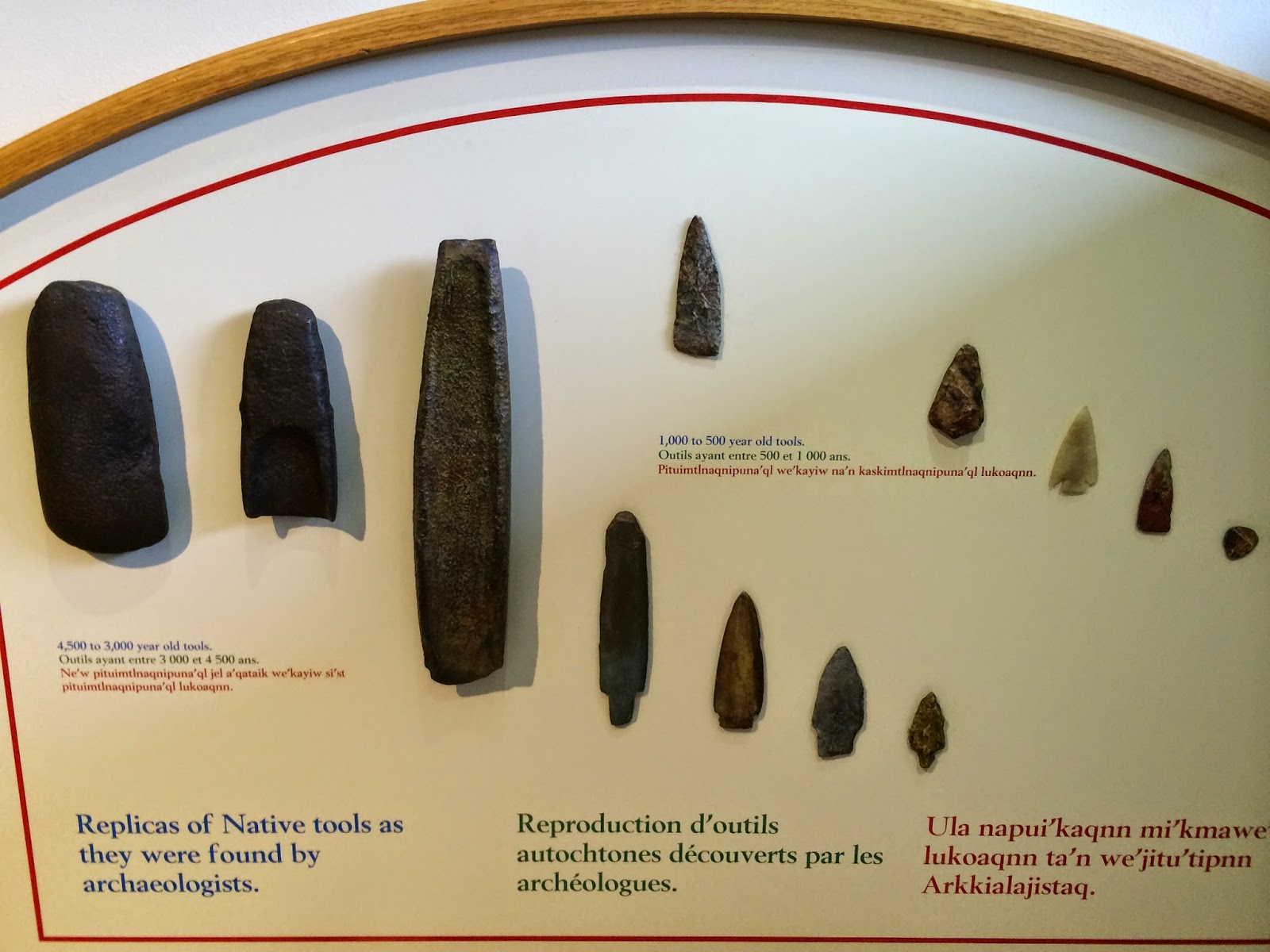
Bill Simmons alert!!!

The first three objects above date from 4,500 to 3,000 years ago. The remaining are from 1,000 to 500 years ago.

How the complete tool appeared when it was in use.

After spending time in the Visitor Center we took a short hike.

This single tree had six trunks.


Partway along the trail we came to the highest (!!) falls in the park, Mills Falls (because at one point a man built a mill at the falls). There was also a descriptive sign that talked about why the water is brown and there is so much foam. This is the Mersey River and its brown water is called Mersey tea. Water, seeping through bogs, is stained by organic compounds. The bogs add naturally occurring organic substances to the water. Tannins stain the water brown and saponins are like natural soaps; when they fall over a waterfall they form stable foam.

A little further down the trail we stopped to have our lunch near some rapids.

I think we are getting better at taking selfies. Frederick hods the camera out, since he has long arms, and I push the button.

We are now tucked in our site at the Rayport Campground on the Martins River in Mahone Bay. When we arrived we learned that this family campground was celebrating Halloween, in August. There were Halloween decorations all through the park and there was trick-or-treating from 6:30 - 7:30 pm. We felt terrible that we did not have any candy to hand out. Fortunately, those RVs that were prepared to give out candy were supposed to post a jack-o-lantern picture on their RV so, at least, no one came to our door. We felt a little like Scrooge, but we enjoyed seeing the little kids in their costumes. 

Decorations at one campsite covered more than one site. 

This was the entrance to the office when we arrived. Our first clue that something interesting was happening.

Other campsite decorations. The cat moved its head from side-to-side.

Our site backs right up to Martins River. (I have more pictures but the internet is not good so they'll have to wait.)


Test

Hi Frederick,
Please try to add a comment

Friday, August 22, 2014

Five Cajun guys

Last night about fifty of us gathered at the Fort Anne parking area at 9:30 pm where we each received a candle lantern to carry on the graveyard tour. It was not the Halloween, scare-you kind of tour. It was led by internationally acclaimed heritage interpreter, Alan Melanson; he has been doing this tour for 23 years. A 10th generation Acadian, he uses the tour as an opportunity to talk about the history of Annapolis Royal and the Acadian culture. He also gets in a fair number of encouraging comments about historic preservation. He is a past president of the Annapolis Royal Historical Association and he is justifiably proud of their preservation record. It was also a lot of fun.

People came from all over Canada,  the United States and Europe. We each were given one of the lanterns.

Alan Melanson, a historian and storyteller, in costume, leading us through the graveyard.

Today we crossed the Annapolis River basin to visit Port-Royal National Historic Site; it is also called the Habitation. Port-Royal was the 2nd European settlement in North America. First was Saint Augustine, Florida, by the Spanish, in 1562. Second, Port-Royal, 1605; and, third was Jamestown, Virginia, in 1607. It was originally established as a fur trading venture. An original group, under the leadership of Pierre Dugua, Sieur de Mons, arrived in 1604, but a severe winter and lack of provisions led to the death of almost half of the 79 colonists. In the spring of 1605, another group, accompanied by cartographer and explorer Samuel de Champlain, arrived to find a more suitable location.

After a summer of exploration and on the recommendation of Champlain, the colonists chose to settle on the north shore of the Bay of Fundy, at Port-Royal, a beautiful, sheltered harbor. The area lay within the traditional territory of the Mi'kmaq and the Mi'kmaq and the French began an enduring friendship and alliance. Membertou, the chief of the region, played a central role in forging this relationship. With the two peoples sharing knowledge and customs the French were able to survive. The Habitation survived until 1613 when it was attacked by a British raiding party from Virginia. This site was then forgotten and the French built a grander fort across the river at what became Annapolis Royal (yesterday's blog).

An American, Harriette Taber Richardson, of Cambridge, Massachusetts, frequently visited her cousin who lived in the Port-Royal area. Harriette, an amateur historian, heard the stories of the Acadians and of the first French settlement. One day, while she was out walking in the field across the road from her cousin's house, she found some artifacts from the original fort. She conceived the idea that The Habitation should be rebuilt by the descendants of the colonists who had destroyed the original in 1613. She organized the Associates of Port Royal in 1928. The Depression curtailed her initial efforts but she kept the idea alive until the Government of Canada undertook the project, as a kind of WPA effort, in 1938.


The Canadian government rebuilt the Habitation in 1939-1940 using descriptions and engravings from Champlain's works and detailed studies of the construction methods used in France at the time. It was the first large-scale reconstruction undertaken by the federal government, a milestone in the preservation movement in Canada. 

Individual building surround an interior courtyard.

Costumed interpreters engage the public, especially children. This is Kyle, he is shaving pine boards to become shingles.

Sieur de Mons' residence.


Unemployed and retired shipbuilders were used to erect the buildings using no nails. All the joints are pegged. (Just ignore the sprinkler system pipe used to protect this wooden buildings.)

A moose hide decorated in the Mi'kmaq style. The Mi'kmaq would have used such a hide as a cloak.

The Habitation was built as a fur trading center. This is the Trading Room.

Another moose hide decorated by the Mi'kmaq.

The apothecary room.

A cannon on a platform that that faced the water. Notice the little cannon balls below the gun.

The kitchen. Somehow I think this reconstruction looks a lot better than the original Habitation.

A real pleasure of the day was meeting the five gentlemen picture below. We were walking out of the reconstruction together when I noticed that one man had on a T-shirt with the outline of the state of Louisiana on it and the name Dugas above the outline. We had noticed the name Dugas on the lists of the original Acadians who had been deported. Cheryl Dugas Ethier is the name of our Financial Advisor in Providence. On an impulse, we asked him if he was from Louisiana. It turns out that these five guys are descendants of deported Acadians who settled in Louisiana. They had come to the area on a long-dreamed of trip to see where their ancestors had come from. We then had a long conversation about the Louisiana Acadians and what their culture means to them. They were so friendly and open. Two of the men are brothers, one is their double first cousin (Their mothers were sisters and their fathers were brothers. They say that happens a lot where they come from.) The other two are good friends.


Left to right - Shane Dugas, Russell Breaux, John DelCambre, Mac Dugas and Ken Dugas. Five really nice guys!

After lunch we continued to the Bay of Fundy shore, about 15 miles northwest of Annapolis Royal, at  the end of the road at Delaps Cove. At the Visitor Center yesterday we learned of a wilderness trail that would take us to a waterfall.  

A portion of the trail goes along the coast. At one section, people had erected these versions of inukchuk. We stopped to build one too, it's in the lower right of the above picture.

The tide was out which means that the water was about 27' below hight tide. In this cove, the rounded rocks were all colored green and it looked like a bowl of peas. At high tide they would all be under water.

Bohaker Falls on the Delaps Cove Wilderness Trail.

Thursday, August 21, 2014

Tapestry

We began our day visiting the only tidal power plant in North America, the Annapolis Royal Tidal Generating Station. They are celebrating their 30th year of operation on Saturday and we have been invited to attend their party where we can get a hamburger flipped by the President of Canada's Hydro  Power Company. It began as a demonstration project in 1984 to produce electricity by harnessing the tidal waters of the Bay of Fundy. 

This is Henry with the scale model of the hydro generating turbine. He obviously loved talking about the process and we learned quite a lot.

View up the Annapolis River that forms the "head pond" that flows through the generator at times of receding Bay of Fuday tides. They are able to create hydro power during two, 6-hour tidal periods a day.

Canada's oldest national historic site and a key battleground during the 17th and18th centuries when England and France were battling for the control of North America. It was a key battleground where there were 13 battles, with the Fort changing hand seven times.

The French were the first to establish a colony, Port-Royal Habitation, a fortified trading post at the mouth of the wide Annapolis River in 1605. In response to the harsh living conditions, the French established a social and dining club, the l'Ordre de Bon Temps (Order of Good Cheer), a first for North America. The decadent good times didn't last, however, as an expedition from the English colony of Virginia attacked and burned the settlement in 1613.  The French rebuilt an even more grandly fortified Port-Royal a few miles upriver, in 1636, and it became the capital of the French territory in Nova Scotia.

In 1621, King James issued a charter of New Scotland to Sir William Alexander, a favorite of the Stuart Kings. The charter was for the territories of Nova Scotia, New Brunswick, Prince Edward Island and the Gaspe Peninsula. Along with the charter, the territory was also granted its own flag and crest. But, as you know from the above, this was territory already claimed by the French. However, these Scottish settlers established their settlement, known as Charlesfort, in 1629. This settlement was abandoned to the French under the terms of the treaty of Saint-Germain-en-Alye in1632. 

During the latter part of the 1600s, more French came to settle the land in this valley and they became known as the Acadians and developed their our culture. The French Fort at Port-Royal was subject to frequent attacks and capture by British military only to be restored to the French by recapture or treaty stipulations.  In 1702, the French began building a bastion fort, designed by Vauban, the undisputed European fort design master of his time, at Port-Royal which was captured a final time by the British in 1710. The British renamed the town Annapolis Royal and rechristened the fort as Fort Anne in honor of the British Queen Anne. Under the Treaty of Utrecht in 1713, Acadia (Nova Scotia) was granted to the British. In the 1740's, the French sent three unsuccessful expeditions which involved some of the resident Acadians. 

In the run-up to the Seven Years War, in 1755, the British Governor Lawrence and his Council, ordered the deportation of the Acadians because he felt they were French sympathizers and could not be trusted. The Acadians were taken to other English colonies to the south. After deporting the Acadians, Governor Lawrence lured English-speaking Protestants to Nova Scotia with offers of fertile land. New England settlers or Planters, began arriving in 1759. Some established themselves as fishers, but most settled on the vacant Acadian farms. Most Planters who settled in Annapolis Royal are from Massachusetts. By the end of 1768, there were about 8,000 Planters in Nova Scotia. After the Seven Years War, the Acadians were allowed to return but they were not permitted to reclaim their former lands and had to settle elsewhere in the colony. 

In 1749, the political and military focus of the British was moved from Annapolis Royal to Halifax and the fort declined in importance. In 1790 there was a brief revival and the Field Officers Quarters, the only remaining building, was built. This revival was short-lived and the fort fell into decay until the 1890's when local citizens organized to save the fort.


The obligatory cannon at the entrance to Fort Anne.


The prized exhibit in the Visitor Center is The Fort Anne Heritage Tapestry. Designed by Kiyoko Grenier-Sago and stitched by over 100 volunteers, including several stitches by Queen Elizabeth, the tapestry depicts over 400 years of history in the Annapolis Royal area.

Detail from the bottom left of the 1600s panel.


There are four sections, each section representing a century. Each section was stitched in three parts that were then stitched together. 


The 1800s section. Queen Elizabeth added stitched to the portrait of Queen Victoria.

Detail of the 1800s panel showing the texture that was added to the tapestry.

The final section, the 1900s. You can see an American Flag in the lower left. During a centennial celebration in 1904 all three countries, the British, French and the United States, had a part.

Detail on the bottom corner of the 1900s panel.

One of two copies of the original Charter from King James to Sir William Alexander in 1621.


Diarama of the original Fort Anne.  What remains include well-preserved ramparts and bastions, a powder magazine and a storehouse; these two structures are underground.


Our lunch site overlooking the Annapolis River.

Next to Fort Anne is the public library.

The only remaining structure above ground, the Field Officers Quarters, built in 1790, which now serves as the Visitor Center.

The historic town cemetery located next to the Fort.  We are going for a candlelight tour of the cemetery tonight at 9:30 pm.

Another feature of the town is the Annapolis Royal Historic Gardens. This seventeen acre horticultural feature presents themed gardens representing different periods in Annapolis Royal's history. 


Sculpture is a part of the gardens. This sculpture is called, "The Dance of the Blue Herons."

There was a sign next to the sculpture that described the damage done by Hurricane Arthur in early July. A tree limb from the tree on the right, you can see the scab on the tree, fell and damaged the left wing of this crane. Previously the left wing had been raised to match the right wing.

A replica of a 17th century Acadian home, with bake oven and a partly thatched roof, surrounded by a traditional "potager" and orchard. 

The interior.


Another artist designed 33 ceramic birds and placed them in a quiet grove of trees and shrubs.

We were challenged to find all 33. 

We didn't find them all.


A portion of the pine forest.

The Scotch heather collection.

The Rock Fountain made from rock specimens indigenous to Nova Scotia.

As we learned from a Library Conservator Event, August is not an especially good time for gardens. The only colorful garden was the Victorian garden filled with curved beds filled with showy annuals that would have been rare and exotic a century and a half ago.

Colorful begonias.